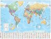
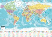
Fully updated world map to include the latest political changes. Contains politically coloured mapping showing each country and their capital city, major roads, railways and cities and towns clearly. Also included are national flags, key statistics for every country and inset maps of the polar regions.
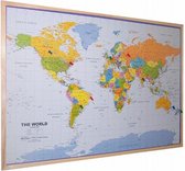
This laminated (on front side only) map is printed on high quality paper and comes rolled in a plastic tube – ideal as a poster for any classroom, bedroom or office wall.
Area of coverage: All of the world, centred on the Greenwich Meridian, and including maps of the North and South Pole regions.
Scale: 1:22 000 000; 1 cm to 220 km; 1 inch to 347 miles
Size: 1015 x 1380 mm (40 x 54 inches)
Other versions available: Paper flat map in tube (ISBN 978000821158-5).
Negatief, positief, neutraal: we zetten een review altijd online. We controleren wel eerst of ’ie voldoet aan onze reviewvoorwaarden en niet nep is. We controleren ook of ’ie is geschreven door iemand die het artikel heeft gekocht via bol.com en zetten dit er dan bij. De controles gebeuren automatisch, al kijken er soms mensen mee. Bol.com betaalt niet voor reviews. Als een reviewer door een andere partij is vergoed, staat dit in de review zelf.
Kies gewenste uitvoering
Bindwijze
: Onbekende bindwijze
Prijsinformatie en bestellen
De prijs van dit product is 18 euro en 99 cent.18
99
2 - 3 weken
Levertijd
We doen er alles aan om dit artikel op tijd te bezorgen. Het is echter in een enkel geval mogelijk dat door omstandigheden de bezorging vertraagd is.
Bezorgopties
We bieden verschillende opties aan voor het bezorgen of ophalen van je bestelling. Welke opties voor jouw bestelling beschikbaar zijn, zie je bij het afronden van de bestelling.